A severe thunderstorm develops in west-central Wisconsin and travels nearly 180 miles across the state producing large hail and a wall cloud.
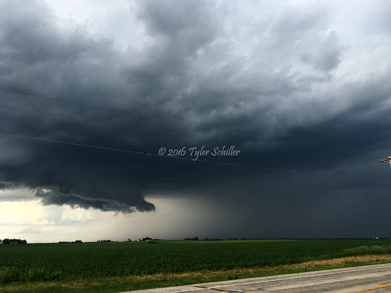
Waupun, Wisconsin - Wall Cloud
There was a slight risk for severe thunderstorms throughout the afternoon and early evening for most of central and eastern Wisconsin. My storm chasing partner, James, met up at the Hartland, Wisconsin Park n Ride to carpool and target Endeavor, Wisconsin.
A pair of multicell thunderstorms developed across central Wisconsin and moved southeast thanks to a low pressure system and cold front. The storm on the southern flank had become severe as it was moving southeast around 30 mph. We decided to intercept this storm near Endeavor, Wisconsin and had watched it move towards our location. We parked on the side of the road facing north and noticed a lowering. We watched it and then went east on highway O to keep up with it. The lowering drastically improved its structure southwest of Montello, Wisconsin. At this point the computer models were forecasting a favorable environment for supercells between 6-8pm.
Suddenly the storm began to weaken. The wall cloud lost its definition and the storm as a whole stopped moving southeast and turned more easterly. While still traveling east, we were thinking about calling it a day, but kept going anyway.
However, the wall cloud began to develop more of a beaver tail/inflow band into the updraft. At the same time, the radar presentation indicated a restrengthening storm. We pulled over and the wall cloud began to wrap the rear-flank downdraft around it base and rotation was more apparent in the storm. The radar indicated increased gate to gate shear and we were waiting for a tornado warning.
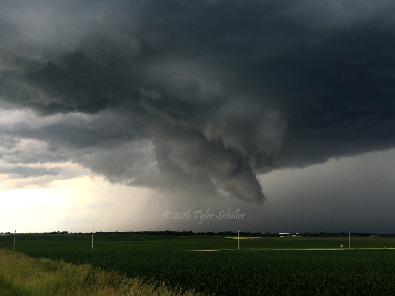
The storm was nearing Waupun, Wisconsin and the wall cloud had a broad rotation and a tornado didn't appear imminent. We had to reroute around the city due to road construction and got behind the supercell. We noticed the wall cloud was shrinking but it had tightened its rotation. We stopped east of the city and saw a small, rapid rotation where the updraft was located. I took a timelapse and it was evident, however, we still thought the rotation wasn't fast enough to produce a tornado.
We headed back home since the storm was getting closer to Lake Michigan. Not a bad first chase of 2016!
Make sure to browse the chase logs section for additional Storm Chasing Fever Chasing Adventures.


 A pair of multicell thunderstorms developed across central Wisconsin and moved southeast thanks to a low pressure system and cold front. The storm on the southern flank had become severe as it was moving southeast around 30 mph. We decided to intercept this storm near Endeavor, Wisconsin and had watched it move towards our location. We parked on the side of the road facing north and noticed a lowering. We watched it and then went east on highway O to keep up with it. The lowering drastically improved its structure southwest of Montello, Wisconsin. At this point the computer models were forecasting a favorable environment for supercells between 6-8pm.
